Question

GIS-integration ESRI ArcGIS - communication setup issues


Forum|alt.badge.img+6

Hi,

We have an issue when setting up our GIS-integration with ESRI ArcGIS. 

All firewall and ports are open between IFS App server and our ESRI server.

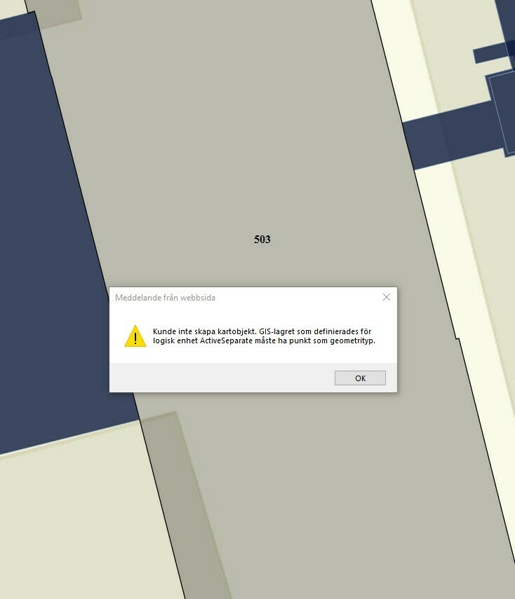
Somehow our layers still don’t load as expected when accessing our GIS-map.

That leads us to suspect that some extra config is necessary, probably on our ESRI ArcGIS-server.

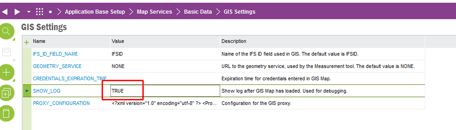
Anyone got documentation descriping technical setup?

Best Regards

Anders

14 replies

Mathias Dahl
Superhero (Employee)
Forum|alt.badge.img+32
  • Superhero (Employee)
  • 2824 replies
  • April 13, 2022

Hi Anders, thanks for posting here.

Firstly, a good starting point for learning about the GIS integration is this process model (this is for IFS Cloud, but should be more or less the same as for Apps 10):

https://docs.ifs.com/ifsclouddocs/21r1/ProcessModels/Process_Model/GISMapObjectConnection.htm?StandAlone=true

From there you can both learn what the flow/process (the "fishes"), and how (activity/process diagrams with the green boxes and their descriptions). You can, and should, also read the three "about documents" that are linked at the top. The best one here I think is the GIS Concepts document that has a lot of details on how to set up various parts of the integration.

Now, from what you write I guess the problem could be that the GIS proxy has not been set up or set up correctly. The document I mentioned above explains how to do that in great detail (search for "GIS proxy").

Are the users running GIS Map on the same network as the ArcGIS servers? Do they have direct access to it? Are all layers public or private (requires authentication), or both? Unless all layers are public, the GIS proxy must be configured. And even if all layers were public, some configuration will be needed even for working with those.

The GIS proxy runs on the IFS application server, regardless if it is IFS Cloud or Apps 10 and requests from that server need to be able to reach the ArcGIS server.

If you use private layers that require authentication, you also have two options: either the users are asked to "log in" once the map opens, or the proxy log ins for them. Both scenarios are described in the documentation mentioned above. In the former scenario, some communication goes through the proxy, but most of the "map loading" will go between the client and the ArcGIS server.

Let me know if you have any more questions. And, if you can, provide as much details of your set up as you can.

Thanks!


Forum|alt.badge.img+6
  • Author
  • Sidekick (Customer)
  • 19 replies
  • April 13, 2022

Thank’s a lot Mathias!


We’ll follow your recommendations / documentation and hopefully get things up and running!


/Anders


Forum|alt.badge.img+6
  • Author
  • Sidekick (Customer)
  • 19 replies
  • April 25, 2022

Hi,

So far we have followed instructions regarding proxy setup.

We are receiving an error message that is hard for me to interpret.

Any recommendations?

//Anders


Mathias Dahl
Superhero (Employee)
Forum|alt.badge.img+32
  • Superhero (Employee)
  • 2824 replies
  • April 25, 2022

Hi @Anders Jansson,

Do you happen to use the Definition Expression feature? If yes, could you try and disable it temporarily  (= remove the expression from that field on the layer) to see if that error goes away?


Mathias Dahl
Superhero (Employee)
Forum|alt.badge.img+32
  • Superhero (Employee)
  • 2824 replies
  • April 29, 2022

@Anders Jansson 

Hi,

I found a way to get some logging information from GIS Map when it loads. It can be enabled by setting the SHOW_LOG setting to TRUE, like this:

After the map has loaded a small pop up window will show a log of some things that happened during the load. Perhaps it will contain information about why the basemap could not be loaded.


Forum|alt.badge.img+6
  • Author
  • Sidekick (Customer)
  • 19 replies
  • May 6, 2022

Thank you for guiding and support Mathias. We are debugging and our base map setup with arcgis online currently.


Parallell to this we are trying to setup geolocation of work orders in this solution.


When doing this we run into error message below. What does this tell us? Is there an action on the IFS side or the GIS-side that is required?


//Anders


Mathias Dahl
Superhero (Employee)
Forum|alt.badge.img+32
  • Superhero (Employee)
  • 2824 replies
  • May 6, 2022

@Anders Jansson 

The error tells us that, for some reason that I cannot remember (some technical limitation or problem hard to work around, or simply lack of time), the operation you are trying to use only supports point-based feature layers.

I suspect you try to create a fault report from the map, am I right?


Mathias Dahl
Superhero (Employee)
Forum|alt.badge.img+32
  • Superhero (Employee)
  • 2824 replies
  • May 6, 2022

One workaround is to create the fault report/work order as usual, then connect the GIS object with the new WO.


Forum|alt.badge.img+6
  • Author
  • Sidekick (Customer)
  • 19 replies
  • May 6, 2022

Thanks Mathias,

Two ways forward for us:

  1. Fix layer to support point based interaction (we’ll try that first)
  2. Use your work around

//Anders


Mathias Dahl
Superhero (Employee)
Forum|alt.badge.img+32
  • Superhero (Employee)
  • 2824 replies
  • May 6, 2022
  1. Fix layer to support point based interaction (we’ll try that first)


If I understand correctly what you mean, that will not work. You tried to create a fault report on a polygon layer, and the error says that feature only work for point layers. I assume you don't want to change the layer into a point layer...


Forum|alt.badge.img+6
  • Author
  • Sidekick (Customer)
  • 19 replies
  • May 6, 2022

OK! Thanks!


Mathias Dahl
Superhero (Employee)
Forum|alt.badge.img+32
  • Superhero (Employee)
  • 2824 replies
  • May 6, 2022

You can of course look into doing a customization, allowing creating fault reports also for polygon layers. This might or might not work depending on the reason we decided not to support it...


Forum|alt.badge.img+9
  • Sidekick (Employee)
  • 29 replies
  • January 26, 2024
Mathias Dahl wrote:

Hi Anders, thanks for posting here.

Firstly, a good starting point for learning about the GIS integration is this process model (this is for IFS Cloud, but should be more or less the same as for Apps 10):

https://docs.ifs.com/ifsclouddocs/21r1/ProcessModels/Process_Model/GISMapObjectConnection.htm?StandAlone=true

From there you can both learn what the flow/process (the "fishes"), and how (activity/process diagrams with the green boxes and their descriptions). You can, and should, also read the three "about documents" that are linked at the top. The best one here I think is the GIS Concepts document that has a lot of details on how to set up various parts of the integration.

Now, from what you write I guess the problem could be that the GIS proxy has not been set up or set up correctly. The document I mentioned above explains how to do that in great detail (search for "GIS proxy").

Are the users running GIS Map on the same network as the ArcGIS servers? Do they have direct access to it? Are all layers public or private (requires authentication), or both? Unless all layers are public, the GIS proxy must be configured. And even if all layers were public, some configuration will be needed even for working with those.

The GIS proxy runs on the IFS application server, regardless if it is IFS Cloud or Apps 10 and requests from that server need to be able to reach the ArcGIS server.

If you use private layers that require authentication, you also have two options: either the users are asked to "log in" once the map opens, or the proxy log ins for them. Both scenarios are described in the documentation mentioned above. In the former scenario, some communication goes through the proxy, but most of the "map loading" will go between the client and the ArcGIS server.

Let me know if you have any more questions. And, if you can, provide as much details of your set up as you can.

Thanks!


Hi @Mathias Dahl 
I tried accessing the link on here for the documentation but it does not work
could you please help me


Mathias Dahl
Superhero (Employee)
Forum|alt.badge.img+32
  • Superhero (Employee)
  • 2824 replies
  • January 29, 2024

Reply


Cookie policy

We use cookies to enhance and personalize your experience. If you accept you agree to our full cookie policy. Learn more about our cookies.

 
Cookie settings