Question

GIS Objects to Equipment Objects....


dfsjmarchant
Sidekick (Customer)
Forum|alt.badge.img+8

Hello,

I’m trying to understand why the map position that we have loaded into the GIS Map for our assets is not pulling across into the Equipment Object Navigator. 

In the example below, you can see we’ve mapped a turbine:


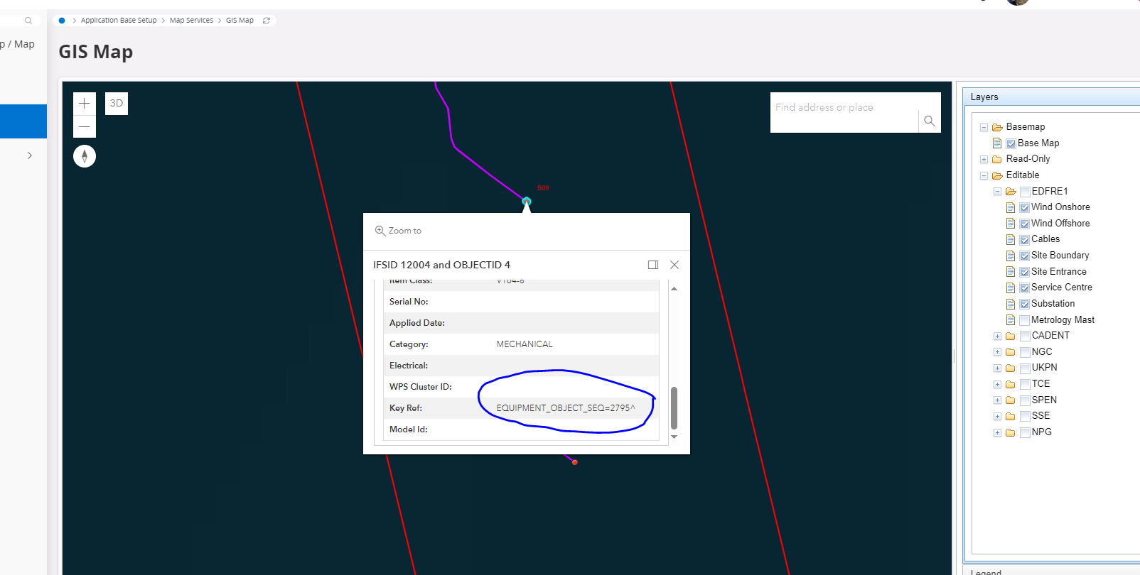
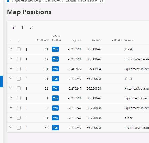
This is linked to the equipment object 2795.
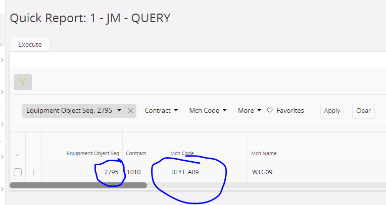
 

This is correct. 

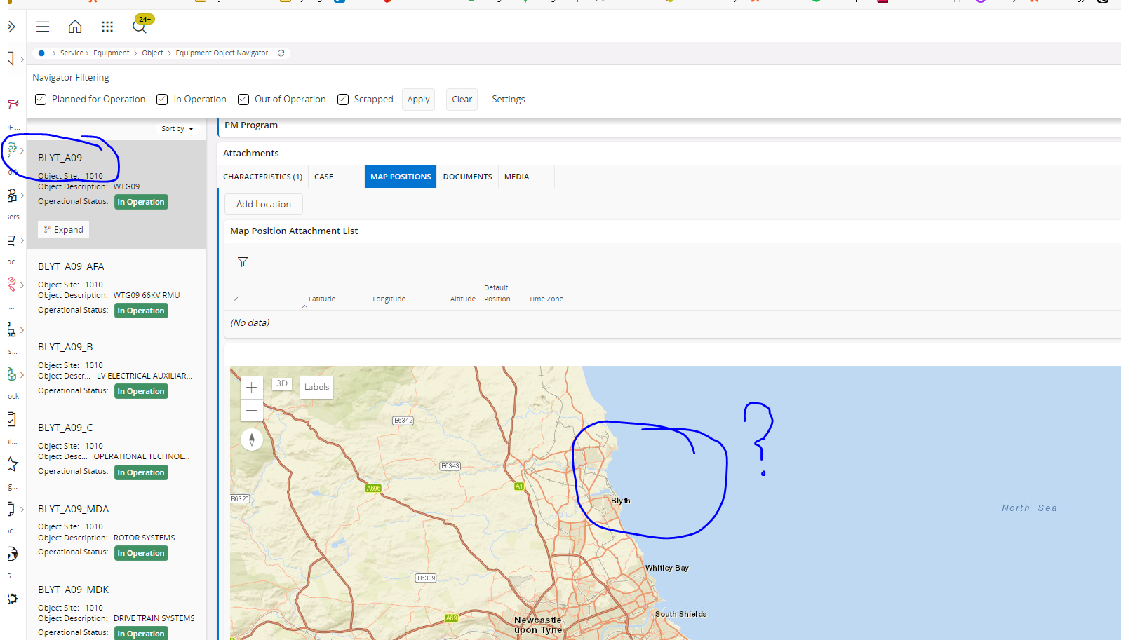
If you then go to the Equipment Object Navigator… there doesn’t appear to be any reference to this connection. I would expect to see the location of the object loaded…

There should be a dot loaded on the screen below I’d have thought.


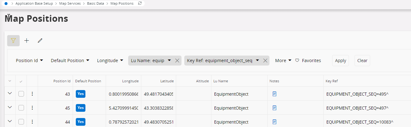
What do we need to do in order to display the turbine position here?


17 replies

Mayura Wasantha
Superhero (Employee)
Forum|alt.badge.img+18
  • Superhero (Employee)
  • 470 replies
  • December 10, 2024

@dfsjmarchant  Could you please check whether you have a respective record in the Map Positions table?

For example, 


dfsjmarchant
Sidekick (Customer)
Forum|alt.badge.img+8
  • Author
  • Sidekick (Customer)
  • 33 replies
  • December 10, 2024

Well, no, we don’t…. we have a few….

But, the idea is that we shouldn’t have to populate all these… if we’ve already loaded them in the GIS part of the application?

If so… do you know why? As that’s a lot of work for us to maintain two databases of GIS data.


Mathias Dahl
Superhero (Employee)
Forum|alt.badge.img+32
  • Superhero (Employee)
  • 2826 replies
  • December 10, 2024

@dfsjmarchant 

Hi,

It looks like you expect the positions that you see and add in GIS/GIS Map to end up under Attachments / Map Positions. They won't.

In the former case, all the geographic information is kept in Esri's ArcGIS platform. In the latter case, the map positions are stored in IFS.

The two worlds are not synced today and both options are used for quite different things. The Map Positions are mostly used in MWO and our PSO integration. GIS is mostly used by customers who are already Esri and GIS customers for a long time.

It's not impossible to sync both worlds, but it hasn't been done and it's also not on the road map.

I hope this clears things up and I'm sorry to not have better news (you seems to have wanted the "integration" between both features). With this new knowledge you can at least consider if you want to add the "sync" yourself. Depending on your exact needs, it doesn't necessarily be that hard.

Good luck!


Mathias Dahl
Superhero (Employee)
Forum|alt.badge.img+32
  • Superhero (Employee)
  • 2826 replies
  • December 10, 2024

PS. If it helps, you can see what we have in Map Positions as a VERY light GIS. It's a map with dots, and that's it.


dfsjmarchant
Sidekick (Customer)
Forum|alt.badge.img+8
  • Author
  • Sidekick (Customer)
  • 33 replies
  • December 12, 2024

Hi Mathias,

Understood :) That’s OK. What we could do is load the coordinates from our source data with a migration job, I’ll have a word with out CAD team and ask what they can provide, and update.


Kind Regards,

James


dfsjmarchant
Sidekick (Customer)
Forum|alt.badge.img+8
  • Author
  • Sidekick (Customer)
  • 33 replies
  • December 13, 2024
Mathias Dahl wrote:

PS. If it helps, you can see what we have in Map Positions as a VERY light GIS. It's a map with dots, and that's it.


Just a quick one then… we’re asking what we’d actually use the GIS map for? Is anyone finding it useful? Can’t really say I can see a great use for it. Are there any good use cases for it?


Mathias Dahl
Superhero (Employee)
Forum|alt.badge.img+32
  • Superhero (Employee)
  • 2826 replies
  • December 13, 2024
dfsjmarchant wrote:
Mathias Dahl wrote:

PS. If it helps, you can see what we have in Map Positions as a VERY light GIS. It's a map with dots, and that's it.


Just a quick one then… we’re asking what we’d actually use the GIS map for? Is anyone finding it useful? Can’t really say I can see a great use for it. Are there any good use cases for it?

I doubt you will get many replies to that question here from others, but let's hope...

GIS Map might not be one of the most used features in IFS Cloud, but we have a number of customers that have found good use of it. In many cases, they are already using Esri and their ArcGIS platform, so it's natural to bring that into IFS and link different GIS objects to objects in IFS and to be able to navigate to and from the map.

If your need is just to be able to position some object/record in earth, Attachments / Map Positions might be enough for you. While on that topic, what are your needs?

Here's a direct link to the documentation on the GIS integration:

https://docs.ifs.com/ifsclouddocs/24r2/ProcessModels/Process_Model/GISMapObjectConnection.htm?StandAlone=true

Read in particular two of the About documents at the top, the first one lists many of the features and you will find there are lot of them.

https://docs.ifs.com/ifsclouddocs/24r2/ObjectPositioningGISMap/AboutGISMap.htm?StandAlone=true

https://docs.ifs.com/ifsclouddocs/24r2/ObjectPositioningGISMap/AboutGISConcepts.htm?StandAlone=true


Forum|alt.badge.img+3
  • Do Gooder (Customer)
  • 5 replies
  • February 8, 2025

Hi Mathias

We are currently using 23.2.7. In previous versions I have been able to display the label information held in ESRI. In 23.2.7 I can only display a dot from the ESRI file. Is the labels something that is still supported in 23.2.7


Kind regards


George


Mathias Dahl
Superhero (Employee)
Forum|alt.badge.img+32
  • Superhero (Employee)
  • 2826 replies
  • February 11, 2025

@george.gilbert 

You mean the label you can configure in the GIS Layer Mapping screen, right?

I cannot think of any recent change that we have done that should made labels stop working. Which versions do you refer to as “previous versions”? Is it Apps 10? 


Forum|alt.badge.img+3
  • Do Gooder (Customer)
  • 5 replies
  • February 12, 2025

It’s the labels from ESRI’s ArcGis they appear in the screenshot attached but not the one above. We have Aurena, not sure if the ESRI question below also applies.

Regards

George G


Mathias Dahl
Superhero (Employee)
Forum|alt.badge.img+32
  • Superhero (Employee)
  • 2826 replies
  • February 12, 2025

@george.gilbert 

Thanks! In which version did it work? If it broke (that is, you didn't do any changed to the label configuration), then I suggest you file a support case so that we can look into it. As I said, I cannot think of a change that should have affected this, but we might have done some other change that broke this by mistake.


Forum|alt.badge.img+3
  • Do Gooder (Customer)
  • 5 replies
  • February 12, 2025

Hi Mathias

This is our production machine status that does not have ESRI labelling present

Application service update: 23.2.7

Framework service update: 23.2.7

IFS Cloud Web version: 23.2.7.20240605150108.0

IFS OData provider version: 23.2.7.20240605053529.0


Our configuration machine (CFG) references the same ESRI files and displays labels

The CFG status is exactly as the production machine above


Regards


George G


Mathias Dahl
Superhero (Employee)
Forum|alt.badge.img+32
  • Superhero (Employee)
  • 2826 replies
  • February 12, 2025

Thanks! If CFG runs an earlier version of IFS Cloud, it indeed sounds like something broke. Then again, you said CFG has the same "status", and I'm not sure if you include the IFS Cloud version when you say that, or if it's only the configuration...


Forum|alt.badge.img+3
  • Do Gooder (Customer)
  • 5 replies
  • February 13, 2025

Hi Mathias

Yes both CFG and production have the same settings below

Application service update: 23.2.7

Framework service update: 23.2.7

IFS Cloud Web version: 23.2.7.20240605150108.0

IFS OData provider version: 23.2.7.20240605053529.0

Let me know if you need me to log a call

Regards


George G


Mathias Dahl
Superhero (Employee)
Forum|alt.badge.img+32
  • Superhero (Employee)
  • 2826 replies
  • February 13, 2025

@george.gilbert 

Thanks! Then I think we can agree it's not the version of IFS Cloud that causes the problem, right? 

I'm sorry, but I don't know why it fails though. "Something technical"…


Forum|alt.badge.img+3
  • Do Gooder (Customer)
  • 5 replies
  • February 20, 2025

Hi Mathias

Agreed it can’t be the version of IFS Cloud. I will look further this end.

Just one last question you mentioned above "sync" between the IFS map position and the ESRI map position do you know if there is any documentation on this process please.

Regards

George G


Mathias Dahl
Superhero (Employee)
Forum|alt.badge.img+32
  • Superhero (Employee)
  • 2826 replies
  • February 20, 2025

@george.gilbert 

I'm afraid we don't have such a syncing mechanism in place. Reading Esri data from inside IFS should be possible via IFS Connect and calling out to the REST APIs on the Esri side. You need to do some PL/SQL programming, set up some routing rule and routing address for that to work. Pushing data to Esri from IFS might be possible as well, but that might be a bit harder (unless IFS Connect can also do POST requests).

All this is left as an exercise to the reader 🙂 


Reply


Cookie policy

We use cookies to enhance and personalize your experience. If you accept you agree to our full cookie policy. Learn more about our cookies.

 
Cookie settings