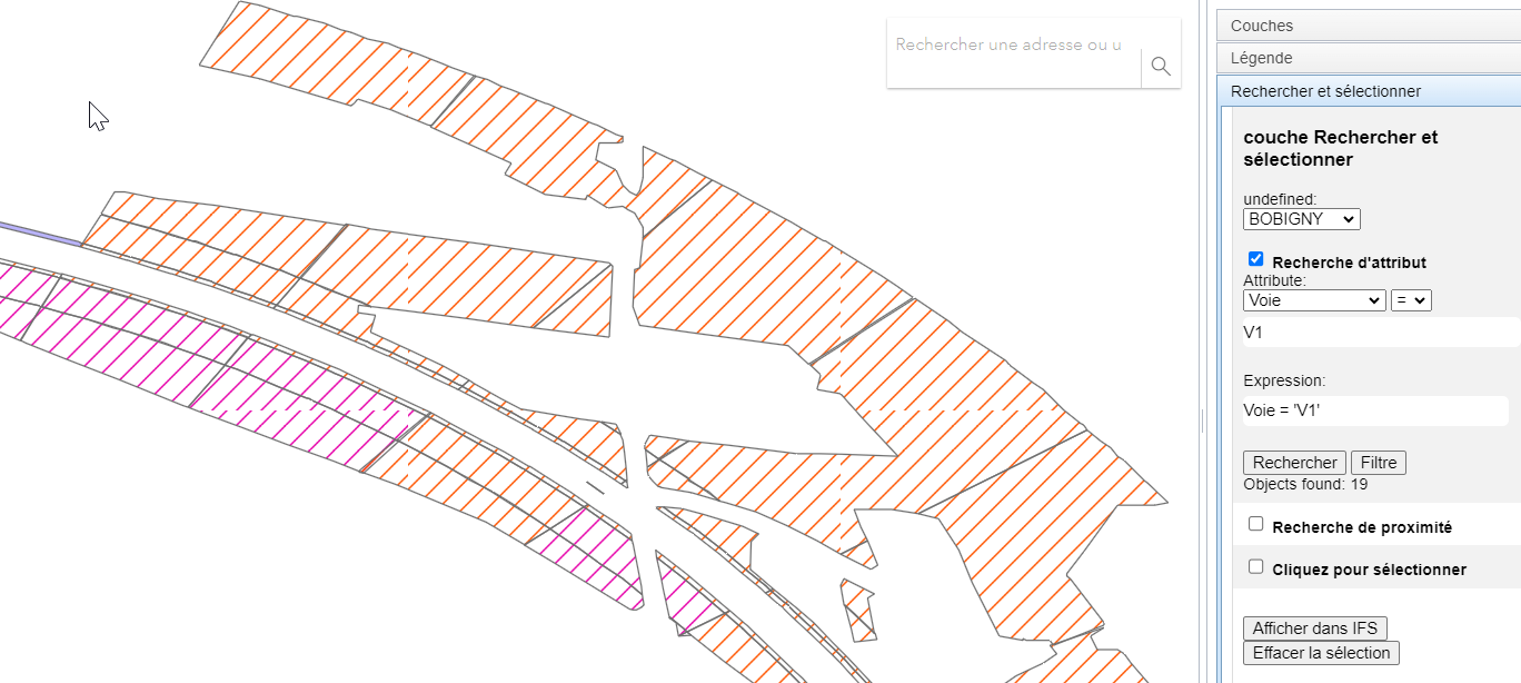
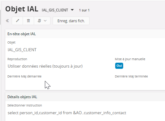
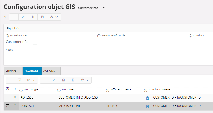
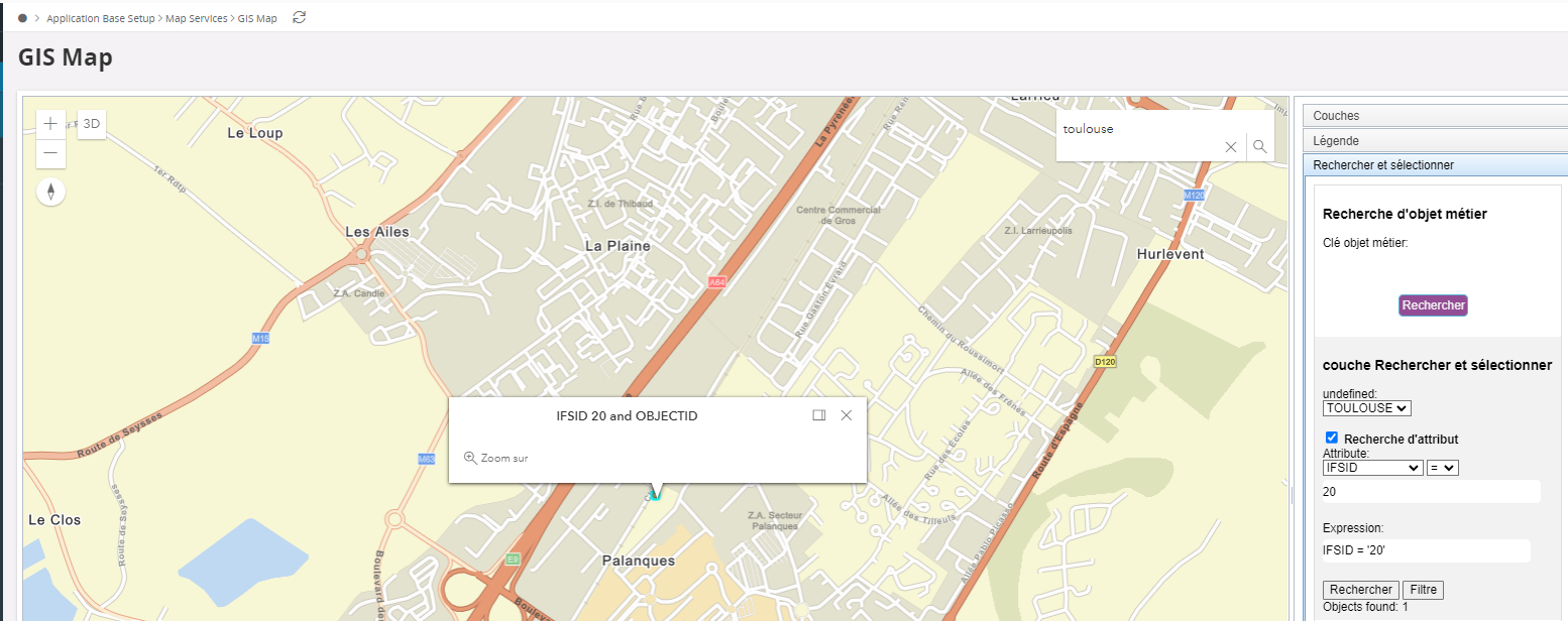
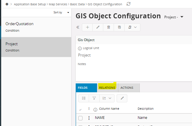
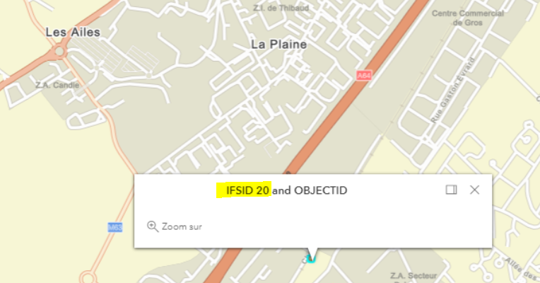
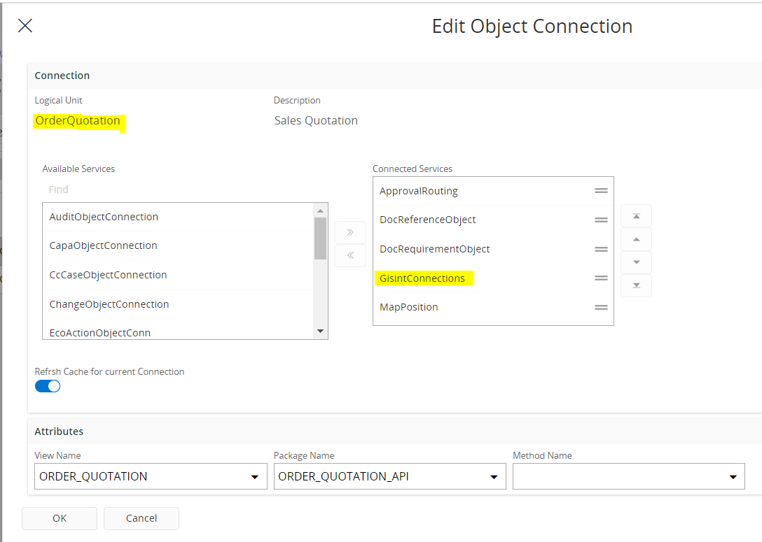
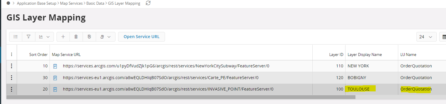
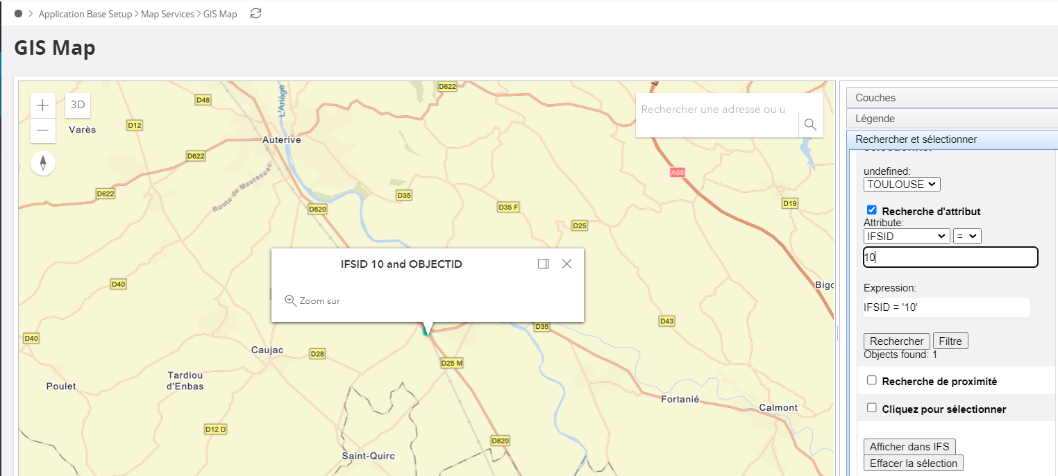
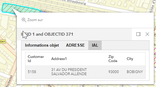
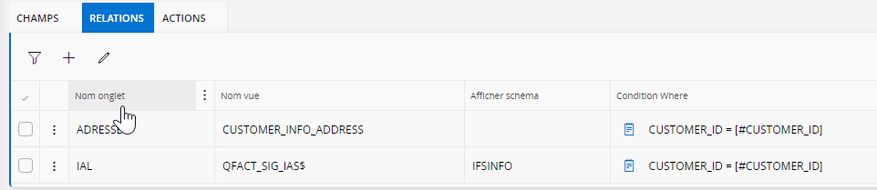
Question

ESRI integration


Show first post

48 replies

Userlevel 7
Badge +30

Yessss! 🙂

It's not good that you were able to save the URL including the layer ID. I'm quite certain we had a validation to stop that earlier, and you would not have got this issue. Would you be able to file a proper support case with us about it? We should also make the field description better, and mention there that the URL should not include the layer ID.

So did this change both enable the linking command as well as displaying the object information? How was the IFSID set on the Esri side?


Userlevel 3
Badge +9

Hi @Mathias Dahl @Nethmini Kosvinna ,

Hi, we continue our GIS integration and we are now on 21R2SU19. We try to use Attribute Inpector but it doesn’t works. do you confirm ?

Managed Cloud Solution


We can use attribute for selection (it find objects) but we not display information.

Christophe

Userlevel 3
Badge +9

Hi,

I can open a support case with these informations : URL Layer and Field description.

I also prepare a documentation, I will share it on this conversation.

Yes, this modification enable the linking command.

On ESRI, we we just create a field IFSID without information in.

Regards, Christophe

Userlevel 7
Badge +30

Does the Esri layers contain a IFSID column yet? They must, or the “integration” will not work.

Setting up the object information dialog is not hard. Is it order quotations you want to show on the map?


Userlevel 3
Badge +9

Hi @Mathias Dahl ,

I try to add IAL informations on GIS Configuration object. So I created an IAL:  

 and use it on 

But I have an error on GIS map. Do you have an idea about correct configuration ?

Best Regards, Christophe

Userlevel 6
Badge +18

Hi @Mathias Dahl ,


Attribute Inspector is not working in 22.1.6 . Could you please confirm from which version this will work in IFS Cloud.

Thanks & Best Regards,

Nethmini

Userlevel 7
Badge +30

Hi, thanks for asking here. The Attribute Inspector is something that had to wait because Esri's new JavaScript API at first did not have support for inspecting the attributes. I actually don't remember if it's now possible to do it and if we have started to use it. I will get someone else to comment here as well.

Userlevel 6
Badge +18

Hi @Jitharie ,
Thank you for your response !.

Best Regards,

Nethmini

Userlevel 3
Badge +9

Hi @Mathias Dahl , Our customer use arcgis.com to manage forest project. Currently I only have a login and password and can connect to arcgis.com

I tried to configure PROOXY_CONFIGURATION but how to be sure about configuration. Where is the log file ?

Userlevel 3
Badge +9

Hi

We succedded to open an esri map with object. But we don’t find how to connect an esri object to an IFS object.

if somebody have idea.

IFS object informationdon’t appear in GIS Map.

Regards,

Christophe

Userlevel 7
Badge +30

Do they want their users to have to log in when the GIS Map opens in IFS or do they want the users to be logged in automatically? The GIS proxy configuration needs to be configured differently depending on how they want to run it. The documentation describes both scenarios:

https://docs.ifs.com/ifsclouddocs/22r1/ObjectPositioningGISMap/AboutGISConcepts.htm#gisproxy?StandAlone=true

Also, can you show the configuration you did? (leave out the username and password or any sensitive part of the URLs)

The best way to know if it works is to open IFS and log in as one of their users and see of the map layers loads in GIS Map. Did you do that? If yes, what happened?


Userlevel 3
Badge +9

Hi @Mathias Dahl

Hi Evevybody

We continued tests et configuration.

Now, it is possible to connect to GIS MAP using ESRI login

We create some map positions

We create GIS connections

In ESRI we added IFSID and add value 10,20,30 on “Points”.

We configure GIS Object  Configuration but we don’t konw how to configure Relations

Do you have information about this step ?

And we didn’t find ESRI points on GIS MAP.

Regards,

Christophe

Userlevel 7
Badge +30

@Pushpa Veerappan @Jitharie @Mayura Wasantha 

Would you know when we added back the attribute inspector to Aurena, if we did?


Userlevel 3
Badge +9

Hi @Mathias Dahl , To be sure about the connection, I prefer to log in when the GIS map open. I attach de proxy_configuration file. On GIS map screen, I haven’t error but nothing load.


Userlevel 7
Badge +30

Thanks!

I am confused. From how it looks, you have the default proxy configuration right now, but you said you tried to change/configure it earlier. Which is it?

Also, can you give an example of a map service URL they want to use?


Userlevel 3
Badge +9

Yes, Esri layers contain IFSID. Yes I want to show Order Quotations informations and others  with Project informations.


Userlevel 3
Badge +9

Hi,

Find my configuration below : 


How to  link IFSID 10 with a order quotation ?

Regards, Christophe

Userlevel 3
Badge +9

Hi @Mathias Dahl @Nethmini Kosvinna @Jitharie 

For information, we upgraded to 22R2SU9 and founded good news !

1 : it is now possible to have ESRI attributs and modify it.

GIS MAP


2 : it is possible to add IAL data

Regards, Christophe

Userlevel 7
Badge +30

Delete the GIS connection you made manually and then click the object on the map. A dialog should open to let you link the IFS object with the GIS object.

Or, add the value of the IFSID in the object in Esri from Esri's own map viewer. That's what we do behind the scenes when we link the two objects.

By the way, it looks really strange to have the layer ID (0, in all three URLs) be part of the URL. It should be set in the Layer ID field. Still it looks like the layers are showing for you, really strange... What are those numbers in the Layer ID field that you added? And were you allowed to save the URL with the layer ID included?


Userlevel 7
Badge +30


Hi @Mathias Dahl @Nethmini Kosvinna @Jitharie 

For information, we upgraded to 22R2SU9 and founded good news !

That's good to hear, thanks for reporting back your findings! 💪🏻 

Userlevel 7
Badge +30

Hi @Mathias Dahl 

is it possible to have ESRI LABEL (info text on polygon) ?

We did add support for defining labels per layer and it used to work in IEE. I frankly don't know if we implemented support for it in Aurena yet. 

Badge

Unfortunately, we have encountered a limitation in implementing the attribute inspector functionality due to the lack of support in the ESRI JavaScript API call. Previously, there was a misunderstanding regarding attribute search and inspector, leading to the incorrect statement that it would be available in the 21r2 version. We sincerely apologize for any inconvenience this may have caused.


Please rest assured that we have recognized the importance of attribute inspector and have duly noted it in our backlog for future development. We are actively planning to implement this feature once the necessary ESRI capability becomes available. Thank you for your understanding and patience as we strive to provide the best possible solutions.

Userlevel 7
Badge +30

I had a quick look in the source code (did not test it) and it looks like the code for adding labels to layers, if labels are defined in GIS Layer Mapping, is still there.

Reply